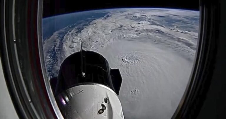
Photos and videos taken from space show the breadth of Hurricane Milton, a massive storm churning in the Gulf of Mexico towards Florida.
The storm is expected to make landfall late Wednesday night or early Thursday morning. While moving over the Gulf of Mexico, Milton has fluctuated between a Category 4 and 5 storm.
Multiple timelapse videos taken by NASA astronaut Matthew Dominick show the storm from the Dragon Endeavour spacecraft. Dominick is a flight engineer aboard the orbiting laboratory, which is attached to the International Space Station. In one post on social media, Dominick said that he had a view of the storm from the window in his sleeping quarters.
The timelapse he shared through that window on Wednesday morning showed the storm as it approached Florida’s western coast. He noted that the storm looked even bigger than it had the day before.
Dominick and three other astronauts were supposed to return to Earth on Monday after a seven-month stay at the International Space Station, but their return has been delayed by the massive storm.
External cameras attached to the International Space Station captured still images of the hurricane. The photo, taken from 257 miles above the planet, clearly shows the small eye at the center of the storm.
NASA
Additional photos shared by NASA’s Johnson Space Center and space station accounts show various views of the massive storm from above.
A longer video captured by the same external cameras shows the station traveling over Hurricane Milton on Monday morning, when it was a Category 5 storm.
The National Weather Service in Tampa Bay described Milton as “a historic storm for the west coast of Florida” that could prove to be the worst to hit the Tampa Bay area in more than a century. Other predictions suggest the storm might make landfall closer to Sarasota.
After landfall, Milton will continue across Florida while rapidly weakening after losing the fuel of the warm Gulf waters, but still maintaining its hurricane status. It would then exit into the Atlantic Ocean before quickly transitioning into a tropical storm Thursday afternoon.
